The heaviest rainfall in Kalgoorlie-Boulder’s history occurred 70 years ago—during the weekend of Saturday-Sunday the 21st and 22nd of February 1948. Nearly 300 millimetres of rain fell in less than 36 hours, causing widespread flooding and severe property damage. A massive clean-up operation followed.
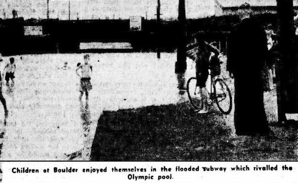
Boulder Subway, note how far the water is from the bridge.
It was nature’s kind of anger,
a weekend of solid rain
From North Kal to Gribble Creek
it caused a lot of pain
Gold mines, town shops and houses,
were inundated by the flood
So too roads and many schools,
and, yes, the Boulder Sub
Stranded were trains out at Zanthus,
so too traffic to the west
The clean-up job enormous;
no time for any rest
Chock-a-block were outlying lakes—
Hannans, Rowles and Gidgie—
Getting there was a problem,
water for miles to see
So, when will all this soaking stop?
somebody popped the question
a cyclone right behind it,
brought on indigestion
Then Lady Luck stepped to the fore,
the storm, it slipped to the east
Townsfolk were mighty grateful—
they’d dodged a bigger beast
So rest-up you folks this summer,
please, no whingeing of the heat
In the total scheme of things,
your goldfields life is sweet
By – John Terrell
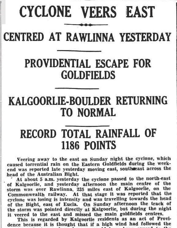
Kalgoorlie Miner newspaper clipping of Monday 23 February 1948.
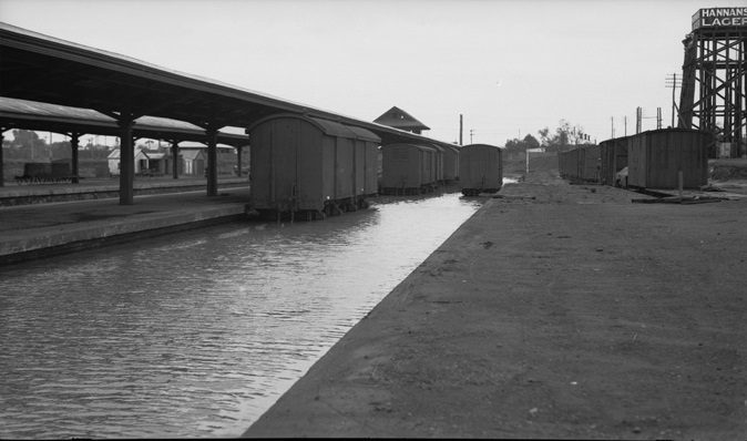
Kalgoorlie Railway Station
Moya Sharp
Latest posts by Moya Sharp (see all)
- A Voice for Women and Children: The Story of Bessie Jordan - 13/06/2026
- The Importance of Being Gordon - 13/06/2026
- A Bolt from the Blue: The Astonishing Experience of William Smith - 13/06/2026
Flood waters to the north & west of Mount Charlotte reservoir flowed south to meet the Trans Line ,embankment, then South West (under the Maritana St. bridge), & flooded over the Railway Platform on its way to Gribble Creek..
Hard to imagine when you stand on the platform these days, as the platform is raised above the terrain.
As a 10 Year old I remember it well – It signalled the end of a drought which lasted from the 1930’s
As far as I know, the Boulder Subway has always been the widest railway subway in W.A.