Australia’s Longest Overland Mail from Meekatharra to Marble Bar.
Western Australia. a distance of 1211 miles for the round trip.
by John K Ewers – February 1935
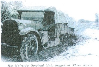
His Majesty’s Overland Mail – Bogged at Three Rivers
Mundiwindi, Murramunda, Bald Hill, Noreena Downs. Nullagine — the very names are redolent of that other Australia which so few people know and which is the most vital and most characteristic and they bring to mind my trip with Australia’s longest overland mail run from Meekatharra to Marble Bar. The trip was made in the spirit of adventure, for no other purpose than to see something of the real nature of the vast Northwest of Western Australia. It was made in mid-summer, under the worst possible conditions of tropical heat, dazzling mirage, and blinding dust. But it has become crystallised as one of the most interesting and exciting experiences of my life.
During those long miles of sweeping plains and rugged hills, I felt somehow that I was nearer the real heart of Australia than I had ever been before. Bogs, blowouts, a broken gear-box, stations, gold mines in lonely places, sheep, cattle, horses, vast brooding solitude, camels, mules, dry river beds and spinifex, always spinifex -such is the country through which the track runs.
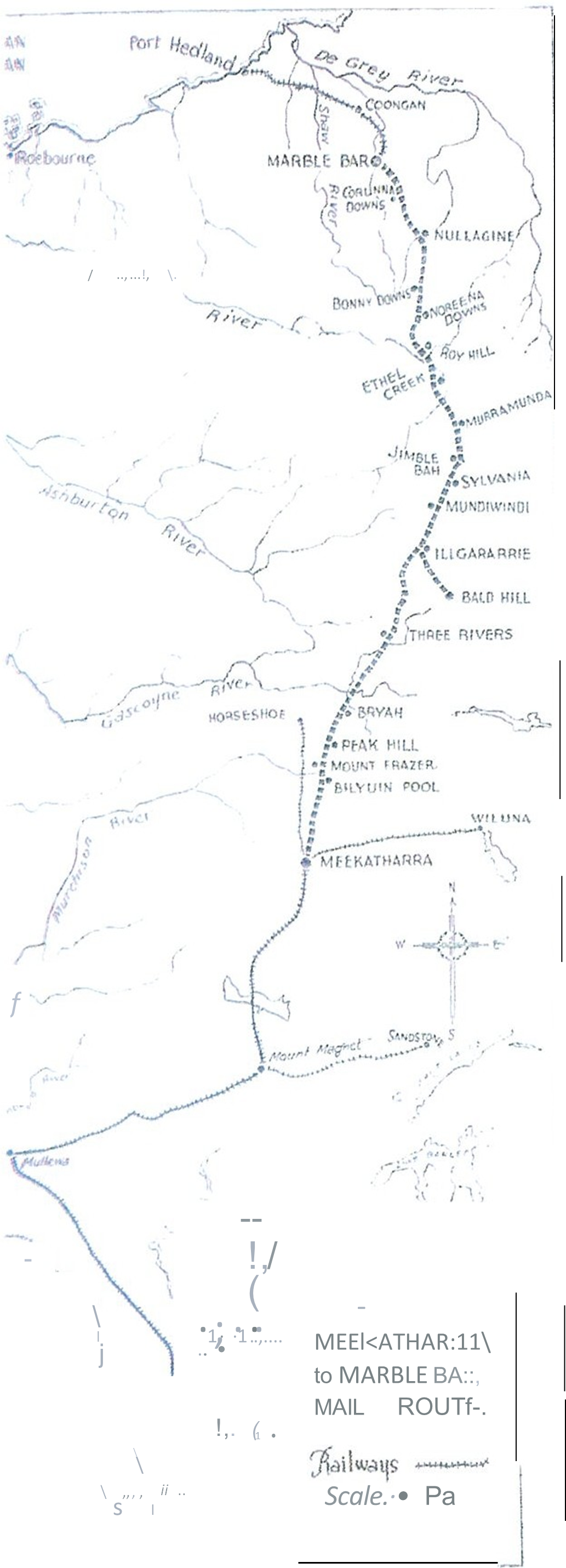
Mail Run Map
But first, you must meet Geoff Lambert, who every fortnight leaves Meekatharra on his long journey of 1211 miles for the round trip to Marble Bar and back. Normally it takes him eight and a half days, but when I met him he had experienced trips that lasted as long as nineteen days. In April last year, just after the phenomenal rains which flooded the North West, I lunched with a sheepman from those parts and when I asked how Geoff was getting on he said
“Geoff left Meekatharra four weeks ago, and they don’t know where he is.”
The lines were down, the roads impassable, but some friendly roof was sheltering the mailman until nature relented and gave him the right-of-way once more. During these “wet” conditions it is a continual race against time. He averages 65 gallons of petrol on the trip, but has consumed as much as 50 gallons on the outward section only from Meekatharra to Marble Bar, a distance of 550 miles. When the engine of his old Dodge chews up the petrol like that, it is hard going, with bogs every few miles and enforced camps on river embankments. “Stayed there four days with nineteen shearers,” says Geoff. “They ate everything in my tucker-box.” “Why do they call it the Savoury Creek” I asked, always interested in derivations. “Dunno” he replies, “unless it is because she can be jolly savory when she likes.”
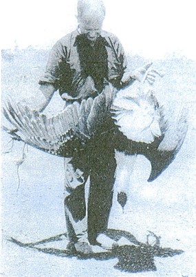
Some sport on the overland route – A wild turkey shot with a revolver from the seat of the moving car.
And then he grins! Years of battling with the elements on those lonely roads have not blunted his sense of humour or robbed him of cheerfulness. Trouble was our second name during the trip I made with him. We left Meekatharra on Boxing Day, and our way led over a stony road from the mining outpost and into a wilderness of tall mulga. Rain had fallen the previous week and pools ringed with grass were plentiful along the roadside. Mobs of kangaroos and emus, and an occasional turkey, started from their feeding at the sound of the car. Fifty two miles out we passed the broad waters of the Murchison at Bilyuin Pool, where an old inn does service along the North-west stock route. At Mount Fraser homestead we experienced the first of the sixty two gates which we had to pass through . These vary from the flimsy cocky-gate, which are in the minority, to the heavily spiked iron frame specially constructed for the discomfort of gate crashers who are in too great a hurry to observe the little courtesies of the road. Many were run throughs, simple devices to deceive the innocent sheep. Some took the form of a letter S, built of brushwood so that no opening was visible. Others were plain openings littered with loose sheets of iron, or trenched with shallow cattle pits covered with evenly spaced iron.
At Peak Hill, thirty miles further on, we lunched at the last hotel until Nullagine four hundred miles ahead. Henceforth the way was through station country, with an occasional isolated mining settlement. At Bryah homestead they told us that a few miles up the track the flats were green with grass following six inches of rain that had fallen three weeks previously. Geoff said that once beyond Three Rivers station there was little likelihood of trouble, but thought we might “have some fun” before we reached it. We did!!! The flats of the Gascoyne River were treacherous six inches off the beaten track. We saw rubble that had been piled two feet high against bushes by the flood-waters. Luckily there was little water in the river itself and we forded it over a hard sandy bottom, only to strike trouble a mile farther on where a new piece of formation traversed a marsh. Geoff had not been on this section before, but truck and trailer went well until in the middle, when they subsided with a sound like a sob. The engine spluttered and stopped. An examination showed that the trailer had swung a foot off the wheel tracks and was stuck fast in black mud. The back wheels of the car were buried to the axels. My diary refers to this briefly as ‘Bogged in south branch of Three Rivers at 4pm, clear by 7:15pm’.
Between the two times. what an expenditure of sweat and blasphemy there was. At half past seven we pulled into Three Rivers, very tired and muddy, and ate a hearty meal under the hospitable station roof. But Geoff liked to camp away from homesteads in order that he could get an early start, so we drove down the river bank a few hundred yards away, where, among myriads of mosquitos, midges, moths and beetles and every flying and crawling thing we made a pretence of sleeping.
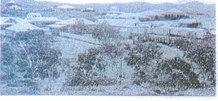
The town of Nullagine
We were up at a five and away soon after, threading our way through magnificent river gums, and over well grassed flats teeming with kangaroos. turkeys and galahs,. Some miles on we stopped to deliver a roadside mail to a couple of sheepmen who had just taken up property thereabouts . We were now among our first spinifex, huge ‘buck.’ spinifex clumps six feet across. We made a detour of 34 miles along a sandy track to avoid a bog that had given trouble on a previous trip, and arrived at Bald Hill at eleven o’clock. That day we lunched by the roadside near a deep creek not far from No. 36 Well. After calling at Ilgarrarie with mail, we made for Mundiwindi a telegraph station on the Savoury Creek. The approach was made through fine river flats and here we saw our first rabbits and a covey of fine wild duck.
However Geoff was anxious to make up for lost time so after conversing with a particularly garrulous cockatoo which are famous throughout the North West, we pushed on towards Sylvania. The car batteries were not functioning, so the headlights shed but a pale glow over the hilly track. Geoff hung his head well out of the car to scan the road, and brought us eventually to where a flood of light poured out of an open doorway and a voice greeted us “Hullo, Geoff, You Old ****, wheres our beer? Here we found a bachelor’s camp of six men , very irascible because the truck carrying their ‘Christmas Cheer’ had been held up at Peak Hill. They fed us like kings and after discussing horseflesh and the beano they were going to have when their beer truck did arrive, we curled up under the stars for the night. There were no mosquitoes here and we slept the sleep of the just.
However, there were disadvantages in staying near a homestead and we could not get away until 7:15am the next morning. A little after eight we were at Jimble Bah, a little mining settlement in a depression between red spinifex clad hills. Low grade ore from six to fourteen pennyweight is found here and a Government Battery had recently been erected. We were soon glad to be out of the heat of Jimble Bah and on our way across the open plains to Murramunda. The country looked very dry after having had only two inches of rain against six further south. This station runs 3,000 head of sheep and cattle but is smaller than Ethel Creek, our next call which covers nearly a million acres and has 9,000 head of cattle. It was difficult to believe that over this parched country a few months later, the rivers would come down in roaring torrents and grass would wave like a sea of green wheat.
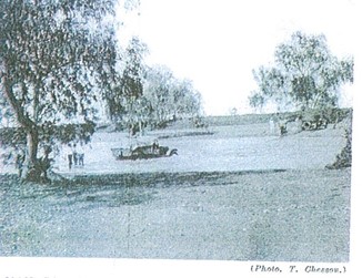
Mail Car crossing the rover 6 miles from Ethel Creek Station.
It was now evident we were north of Capricorn. The mercury stood at 104° when we pulled into Ethel Creek, but heat and dust were forgotten when the mailbags were opened and a hush as of the grave descended upon the station folk as they made contact within the distant south.
We had gone only a few miles beyond Ethel Creek when our second misfortune befell us. A blow out in the middle of the flat faceless claypans that took two hours to repair. On the, right was Battle Hill, the scene of an earlier historic encounter, and the road to the left, miles of claypans gaping with crab holes a foot wide. Towards dusk we crossed the Fortescue over a fine concrete bridge designed so it should be higher than the highest flood waters. Actually this is not so, for torrents sweep over it after every big rain, but it still stands. We did not stay at Roy Hill longer than was necessary than to unload mail and eat a hurried meal, after which we pushed on for 10 miles without lights, losing the track now and then till we found a windmill where we made camp.
Early next morning we were at Noreena Downs, one of the most comfortably appointed homesteads on the run. All the stations have their lawns and gardens for water is plentiful at depths up to a hundred feet, but at Noreena we saw our first Poinciana tree, a blaze of scarlet blossom among ferny foliage. A million acres in extent, this station had shorn 36,000 sheep the previous year. Shortly after leaving Noreena we saw the last of the mulga and entered pure spinifex country, with occasional blond wood, whitewood, snakewood, cork-bark, and of course river gums, along the creek beds. After we had passed Bonny Downs, the landscape became more rugged, and among the red hills we saw our first Euro’s, a species of kangaroo indigenous to those parts, characterised by a reddish tint and a pair of forelegs that appear to be wider apart and more stiffly held than those of the ordinary kangaroo.
Four miles before we reached Nullagine, Geoff brought the car to a stand still and invited me to get out and have a look round. We were on the crest of a rise in the middle of a basin some thirty miles in diameter. The skyline was a magnificent vista of flat topped hills, while the depression was filled with mesas, buttes, and dromedary hills in wild and rugged profusion. There was not a sign of life. Nature held absolute dominion. This is gold bearing country, where both gold and diamonds could be found. When I was here the whole land was in the hands of half a dozen old pensioners. Nearby are the famous conglomerates, unique in world geology which have given to science the name of the Nullagine series. In appearance they are gently rounded hills covered in spinifex but which in reality are a pre Cambrian river bed which in the past has produced pockets of alluvial gold of fabulous value. The hills were pock marked with open cuts and tunnels and were once the scene of great activity. Now Nullagine slumbers by the banks of its river, the cleanest little town in Australia. It comprises a hotel, a post office and a police station and has a population of no more than 20.
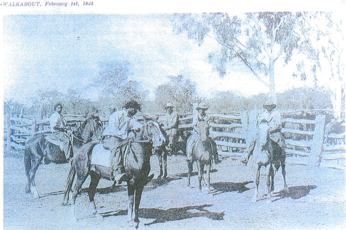
Aboriginal Stockmen
Fifteen miles beyond Nullagine we had our third and greatest misfortune – the top gear selector broke which meant we could go in first or second gear only. This we attempted to do when we found we had lost the crank handle. We ran back several miles in first and second gear with rugged basalt hills reflecting the merciless heat. But it was all to no avail, we didn’t find the crank handle. Back at the scene of out breakdown we set off over 15 miles of plain country towards Spinnaway’s Gorge, the roughest part of our journey. We reached the gorge at sunset but heedless what lay below we raced down the steep grades to give us momentum to get up the other side. There were times when I thought the car would stall but we made it over the worst patches. It was after 8 when we arrived a Corunna Downs where by the greatest of good luck, we found a old Dodge of the same model from which we ‘borrowed’ the whole top of the gear box and the crank handle.
On Corunna Downs there are over 300 miles of fencing of which 90 are on the boundaries. There are 49 windmills pumping water at depths of 20 to 50 ft. Each of these mills has to be visited at least once a week, sometimes twice and after a willy- willy many have to be entirely replaced. Half an hour after leaving Corunna the next morning we were once again in rugged hill country, and the increasing temperature even at this early hour promised a warm time at Marble Bar which we reached at 9 o’clock. The town lies in a depression in the hills, a dry creek bed bordered by white river gums running through the middle. Where one looks the landscape is the same – red spinifex hills against a brilliant blue sky. That day the temperature was 115° at 2pm. At 6pm it was 110° and at 8pm 102°.
Marble Bar is officially the hottest town in Australia. The highest temperature recorded there was 120.5° on the 11th January 1905 and on the 3rd January 1922. It has averaged a temperature of over 112° for the entire month of January in 1910 and 1922. In this torrid atmosphere the town supports about 100 people of whom 78 are men. Gold, Tin, Tantalite and Asbestos are to be found nearby and a five head government battery hammers out a metallic refrain far into the hot and sleepless nights. The town derives its name from a bar of Jasper that runs between the two magnificent bluffs across the Coongan River some thee miles from the settlement. The Jasper is striped red, black and white with some parts resembling strips of fatty bacon. Nearby lies a placid pool of permanent water which the towns people use as a swimming pool after the rains. Due to lack of rain it was too muddy to swim when I was there.
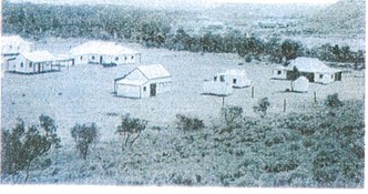
Marble Bar Township.
At Marble Bar I parted from Geoff and Australia’s longest overland mail run as I was northward bound. At dusk on the day we arrived the gallant old car and gallant driver left in a cloud of dust. The return journey would follow the same route with the exception of a detour of over 100 miles from Ethel Creek to Balfour Downs. I heard subsequently that Geoff broke an axel which was not to be wondered at from our reckless gallop through Spinnaways’ Gorge. At Nullagine he sent a wire to his principals at Meekatharra.
‘Having all the fun in the world’
Ref: Walkabout Magazine Feb 1935
Book: To the Bar Bonded by Kathleen Mallett
Book Meekatharra ‘The End of the Earth’ by P R Heydon.
![]()
Leave a Reply