
WHEN THE LEGACY OF EARLY MINING AT KALGOORLIE
CREATED A MODERN PROBLEM
by Doug Daws
This story originally appeared in the “GOLDEN MAIL” newspaper in February 1999. It has been partially rewritten to accurately reflect developments since then.
—-oOo—-
Two apparently unrelated events in 1998 briefly opened a window on a little-known geological curiosity with a link to the way we forged our local courage and spirit. The first was the temporary closure of portion of the eastern by-pass (part of the ‘Goldfields Highway’) near the Kalgoorlie YMCA to allow the urgent filling of a ground collapse which eventually required that portion of the road to be rebuilt.
The other event was the sudden appearance of a hole amid the display at a garden centre then operating in a large old shed on Boulder Road at a location now occupied by modern businesses after the old shed was demolished and the site redeveloped. That old shed was built for the Western Machinery Company that was part of the empire controlled by the famous early day mining entrepreneur, Claude de Bernales.
The cause of both of the subsidence’s was the same – the collapse of the ground above old mine workings associated with early day alluvial deep leads and, water. N.B. The word ‘lead’ is pronounced as ‘leed’ and not as in ‘lead’, the heavy malleable metal. Deep leads might be best described as ancient buried river beds that had deposits of alluvial gold washed into them and accumulated from natural gold occurrences further upstream.
Although relatively common on the Victorian goldfields, alluvial deep leads were not easily recognised in the much more arid Eastern Goldfields of Western Australia. The better known ‘leads’ in the Eastern Goldfields of Western Australia were an early discovery at Kanowna east of Kalgoorlie. The first of these was named the “North lead” quickly followed by the discovery of payable alluvial gold on the South, or what became known as the “Cemetery Lead“, that featured so prominently in the infamous cemetery rush of 1897.
Following its discovery, the miners had followed the South lead right up to the boundary of the original Kanowna cemetery. Realizing the deep lead and, of course, the rich gold located in it continued under the cemetery, pressure was mounted and the miners agitated until the unused portion of the cemetery was officially closed and the ground released for pegging. A new cemetery was first created on the western side of Kanowna so the original could be closed. Eventually Kanowna had the benefit of the discovery of several other deep leads including two known as the “QED” and “Wilson’s Gully“.
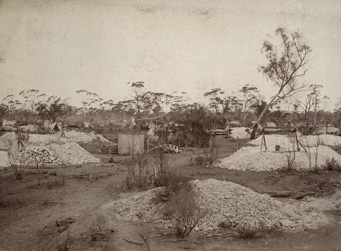
Early Mine Workings at Kanowna – Photo SLWA
Apart from the remnants of the deep leads at Kanowna, perhaps the best known and most easily recognised deep lead is to be seen just south of Broad Arrow adjacent to the Goldfields Highway. Travelers will easily observe the remaining surface evidence as a meandering row of old white spoil heaps visible on the east side of the road to Menzies.
Despite the immense quantities of gold recovered from the Golden Mile there was relatively little alluvial gold discovered. There are two theories why this so. The first is based on the style of geology which is said to be adverse to the formation of alluvial gold. The other proposal is based on the premise that the subtle signs of the buried alluvial were obliterated by the hordes of prospectors that quickly rushed to one of the world’s last great gold rushes. The rapid destruction of the vegetation to make way for the camps and, eventually, the Kalgoorlie townsite on the flats to the west of Hannan’s find, and close to the Cassidy and Maritana (Mt Gledden) hills, would lend weight to this theory.
Nevertheless, sufficient signs were left for those prospectors, either familiar with alluvial deep leads in other places, or with a keen eye, to discover a few. Those identified seemed to follow a westerly trend from the small ironstone rich lateritic knolls along the original north-south ridge marking the gold bearing rocks of an area dubbed, the Kalgoorlie ‘belt’ by the early geologists. The northern end of this linear zone is marked by the Hannans North – now a tourist mine.
The southern end of the Kalgoorlie ‘belt’ is known as the “Golden Mile” although it should be understood that the geology along the ‘belt’ has significant differences from one end to the other. The world-famous Golden Mile is generally accepted to start on its northern end at about the location of the former Croesus gold mine opposite the former Eastern Goldfields High School – now the Goldfields Education Resource Centre. It then extends south for another three or four kilometres to the former Chaffers and Hannans Star gold mines that were located just south of the former Kamballie railway station.
All of these former mines and the railway stations, such as Kamballie on the former “Loop Line”, have disappeared as the boundaries of the Super Pit have expanded and consumed all in its path. The lateritic knolls, or hills, along the Kalgoorlie ‘belt’ are now difficult to find, or identify, as most have been mined for their iron rich gravel which was used to build early local road works or other mining work has further disguised their location.
Some geologists opine that the old ironstone knoll that was quarried as the Monte Christo mine – subject of a recent story featured in “Outback Family History“ – marked the upper eastern end of yet another deep lead. If so, there is no evidence that it was ever mined for gold or followed downwards along what would be a meandering subterranean former creek or river bed. There is no doubt that many of the laterites were auriferous and there remains the distinct probability that the subsequent discovery of gold in some of those early road works is the basis of the legend that the roads in Kalgoorlie are paved with gold.
Perhaps amazingly, one such knoll remains almost intact alongside the eastern by-pass behind the present Bunnings Boulder Road store. This knoll proved to be the eastern end of the “Foundry deep lead” – so named after the large foundry which once occupied the site now containing the Bunnings store, the car park and, the Western Mining assay laboratories.
Now demolished and replaced by a service station, there was a hotel on the opposite side of Boulder Road – the ‘Foundry Hotel’ – that was another reminder of that very large foundry established originally by entrepreneur Claude de Bernales under his Western Machinery banner. The Foundry deep Lead meandered across and under Boulder Road, firstly heading south-west towards that large shed that later housed the garden centre. It then swerved a little and went westerly along the southern margins of Dorethea Street.
In the 1960’s and 70’s, property owners in this street became accustomed to rising in the morning only to discover that perhaps a section of their driveway or front lawn had disappeared overnight. The cause was put down to the effects of watering the lawn or washing the car in the driveway. It was said that the regular flush of water down through the soil washed the finer particles down into the old deep lead workings, weakening the ‘bridge’ and eventually causing the whole lot to collapse from the workings through to the surface.
Vibration from passing motor vehicles is thought to have also had a role in the deterioration of the ground conditions and persistent traffic along nearby Boulder Road no doubt played it’s part as well. We can therefore assume with some confidence, the cause of the subsidence at the garden centre was persistent watering of plants on display, but what about the section of eastern by-pass that fell in causing a serious threat to passing traffic?
Another much more famous deep lead – the “Adeline deep lead” is the culprit here. This deep lead took it’s rise from the lateritic knoll located east of the Eastern by-pass adjacent to the present main access to Northern Star’s offices and treatment plant. The Adeline deep lead tracked south-westerly under the Eastern by-pass and across the northern end of the Education Resource Centre before turning west as it travelled on under the former Shire Civic Centre – now Rydges Hotel – and the former Viewway drive-in theatre on Davidson Street. This area is partly occupied by the current Harvey Norman store.
It is thought that this deep lead eventually terminated on the northern edge of the what we now know as the suburb of Adeline. The evidence for this had been left by the early day miners – a trend of abandoned white dumps – but was removed long ago as housing and roads were constructed. Early historical records of the operation down and along the Adeline deep lead tell us that, in parts, the tunneling was wide enough for two horse-drawn drays to pass side by side. Having been constructed through only naturally compacted soils, and not rock, it is hardly surprising that the material above the tunnels is structurally incompetent.
In the 1950’s all of the liquid waste from the former Eastern Goldfields High School was discharged into the old underground workings of the Adeline Lead as a simple disposal measure before sewerage became available. The Boulder Block road from Kalgoorlie to Fimiston, near the High School just south of the YMCA, collapsed and required filling several times before it was realised that the discharge of the liquids was aggravating an already difficult ground control problem.
Some time after the eastern by-pass was constructed, a deep storm water drain was excavated alongside the road near the Croesus mine. This work inadvertently provided the means for storm water to percolate into the Adeline workings which, at that point, are quite close to the surface. The action of the water combined with the rumblings of the heavy transports along that eastern by-pass reached an inevitable conclusion with the collapse of the road.
There were other important deep leads discovered along the western slopes of the Kalgoorlie belt by the early prospectors. Amongst them, the Ironsides and Ivanhoe Venture deep leads. The Ironsides Lead ran from a point near the former Kalgoorlie State Battery to the west of Federal Road and generally under the land where L&W now operate a hardware store. The Ivanhoe Venture Lead which started near the former Kalgoorlie Electric Power Station in Lane Street Boulder, now a light industrial estate, has a much more notorious history than the rest.
In September, 1899 a dispute broke out over the rights of alluvial miners to take ‘alluvial’ material from leases held by companies who were not so much interested in the alluvial gold as the deeper lodes. Initially the Ivanhoe Venture Lead was the centre of the dispute but a truce was brokered. The truce was broken when, to quote an early reference,
‘the “alluvialists” again assumed an aggressive stance and took possession of the ‘wash’ raised by them’.
Some 500 men with several horses and drays removed the wash for treatment in a puddling plant owned by them at the eastern suburb of Brown Hill. Mounted police were called and an Inspector Newlands addressed the men and asked them to obey the law. This request was rebuffed and the men continued loading drays and shifting dirt all that day despite several of their number being technically arrested and immediately released from custody by the crowd.
The News ‘Adelaide SA’ 24 August 1934, page 6
The police sensibly withdrew whilst they waited for reinforcements. In fine goldfields fashion, the men refreshed themselves with beer supplied gratis by a neighboring publican! The Ivanhoe Venture Alluvial dispute grew into one of the largest public protests in our then young state’s history. Armed police were sent from the coast by train. Several public assemblies were conducted with up to 8,000 present and many were arrested including a Daniel Shea and others with an Irish background.
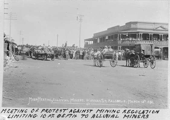
Protest Meeting of miners against the 10ft depth regulation for Alluvial Miners.
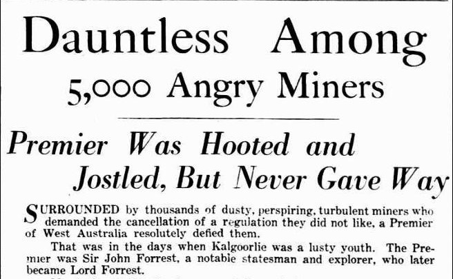
Those arrested were secured in the Kalgoorlie lockup by a strong cordon of police armed with rifles and bayonets. Eventually their leader, a Malachi Dwyer, was also arrested and the whole lot were remanded for eight days and sent to Fremantle. This didn’t help at all and the trouble was far from over. On 26th October, 1899 a monster demonstration with an estimated ten thousand men present assembled on the Kalgoorlie recreation reserve (perhaps the present day Sir Richard Moore Sports Centre) where civic leaders fired a ‘broadside’ at the government of the day. A young man and orator, one F C B Vosper, the first member for the parliamentary seat of North East Coolgardie, gave a particularly fine speech which helped to defuse what had become a most serious situation.
Contemporary reports suggested that the tension was so great that it was only by a miracle that a revolution outrivalling the memorable Eureka Stockade was averted. Vosper must have cut quite a character with his long hair which he refused to cut after being gaoled over his involvement in the earlier Queensland shearing dispute. Eventually the state Premier, John Forest, came to Kalgoorlie where he was confronted by a huge crowd of angry prospectors and alluvialists who had assembled outside the Kalgoorlie Railway station.
In the end the Government were forced to annul the infamous “ten-foot” regulation which had started the dispute. Peace was restored and the imprisoned men were released but by this time the new gold discoveries in the distant Klondike in Canada had become well known. Hundreds of the best and wealthiest miners, disgusted with the government’s action in the whole affair, left the district.
Prospecting in Western Australia sustained a great loss through their departure.
The stupidity of the government in connection with the alluvial trouble left a feeling of intense disgust and indignation in the Goldfields populace, eventually affecting the way we voted, only a short time later, on the Referendum for Federation.
With town development now overlying the area perhaps containing the remaining buried alluvial gold deposits and their tell-tale ironstone knolls now hidden behind the mining companies fences, the prospect of further discovery and work on our largely unknown deep leads is unlikely. The potential for future collapses of roads and residential properties over the mined old leads remains.

Moya Sharp
Latest posts by Moya Sharp (see all)
- The Roaring Gimlet and the Rush to Menzies - 06/06/2026
- The Hash House Riot of Ford Street - 06/06/2026
- Bobby Budgeree: The Bush Doctor of the Dreaming - 06/06/2026
Leave a Reply