
Rediscovery of Hunt’s Historic Slate Well – by Eric Hancock
The historic Hunt’s Slate Well which has been lost for over 100 years was uncovered on Tuesday 24th May 2022. This well was the most easterly of a series of wells created by the party of Charles Cooke Hunt in 1865. The site has huge heritage significance as the first physical development in the now City of Kalgoorlie-Boulder area by people of the early Colony of Western Australia. Hunt’s wells, dams, and tanks (excavated hole with bank) and a track later enabled access to the area resulting in the discovery of gold at Coolgardie in September 1892 and at Kalgoorlie in June 1893.
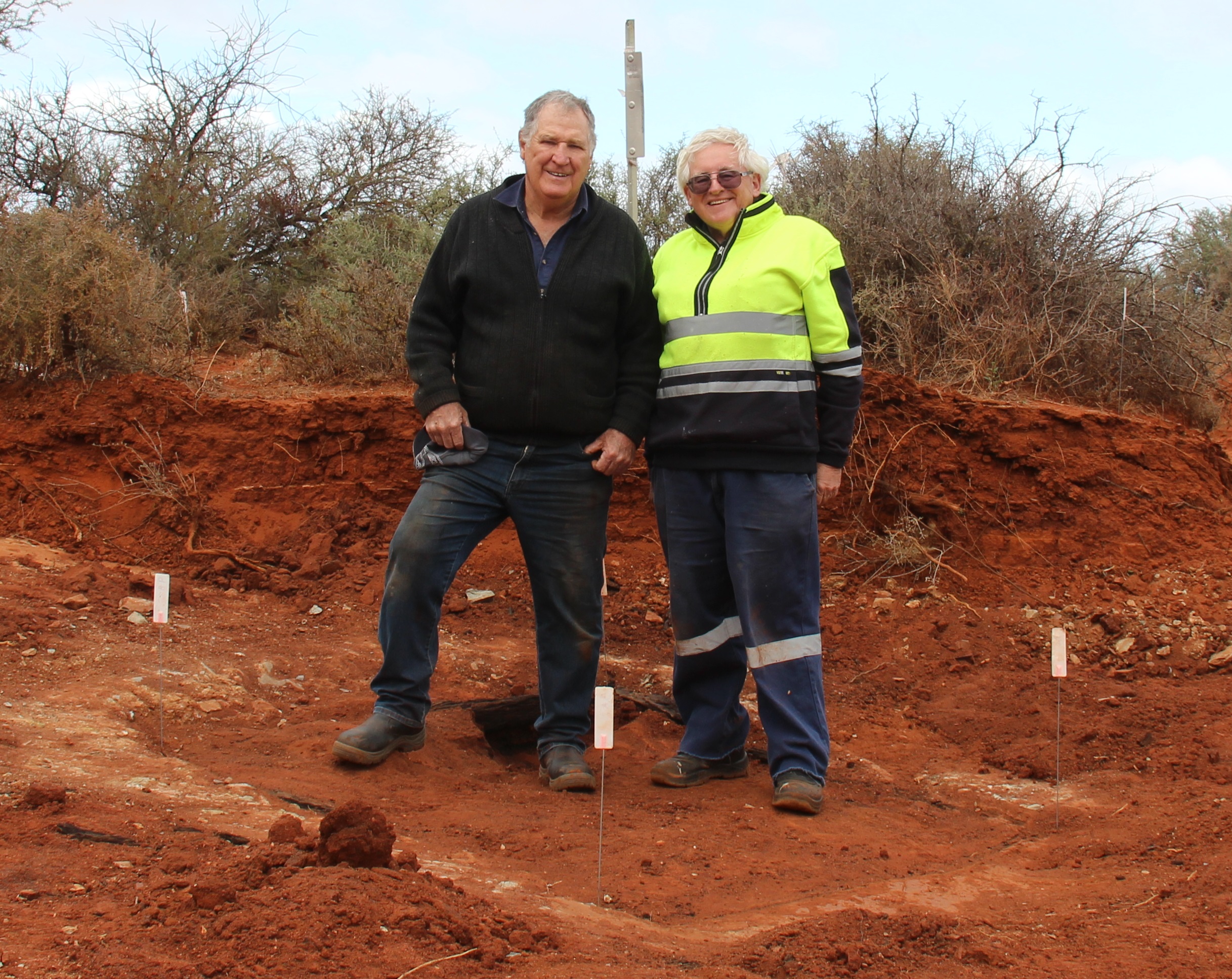
Peter Green Left Eric Hancock Right on Slate Well
Following the 1863 discovery by Henry Maxwell Lefroy of the Hampton Plains as potential pastoral land, Hunt was tasked with exploring and providing access to lands east of York. In 1864 York was the most easterly developed farming area and in that year Hunt made two exploration trips reaching about 100 kilometres east of now Kalgoorlie. In 1865 Hunt was commissioned by Government to clear a track from York to the Hampton Plains and sink wells at convenient intervals. His well-supplied party consisted of six pensioner soldiers, eleven probationary prisoners, and an Aboriginal guide. Over nine months Hunt’s party cleared tracks and developed around 33 permanent water supplies for around 500 kilometers from York as far as Lake Lefroy.
In June 1865 Hunt described in his journal that he had set the men to work sinking a well in a gully in a wide extent of flat. The ground was composed of layers of slate (schist which is a sedimentary rock) and it was hard work to get a hole down to blast. After four days of work, sinking the well was discontinued at a depth of 15½ feet without striking water and having used all the blasting powder. He wrote, “In connection with the well, I have had the gully dug out to form a small tank at the 1st of rain both must become full of water, the tank being 40 feet long by 4 broad and 3 feet deep”.
Hunt called it Slate Well, however, it was later also called Slate Well Tank. Hunt also constructed a tank about one mile further south that he called Slate Tank sometimes causing confusion between the two places. Hunt described Slate Tank as being formed by clearing out a deep clay hole in the bed of a gully and throwing up a strong embankment on the lower or southern side – length (35) feet – (10) feet broad and (5½) feet deep. Slate tank does not appear to have survived the 1890s gold rush.
Slate Well did survive but was fallen in and in poor condition. In November 1892 just two months after the discovery of gold at Coolgardie surveyor Noel Murray Brazier surveyed the track and wells noting; “We were several days looking for Slate Well, which ultimately was found, completely surrounded by scrub, in the bed of a small creek flowing through a wide samphire flat into Lake Lefroy”.
The last record of people using Slate Well appears to be in 1897. The construction of a large tank at Wollubar in 1897 provided ample water for the area and it is likely that unreliable water sources such as Slate Well were bypassed and no longer maintained. Being in the bed of a creek Slate Well would have required regular removal of silt from floodwaters and a period of no maintenance resulted in it being completely covered.
On 5th September 2021, the site was rediscovered by Eric Hancock and friend Peter Green. Eric is a volunteer member of a National Trust’s committee classifying places that have heritage significance and are worthy of conserving for future generations. For the past few years, Eric has been researching Charles Cooke Hunt and his substantial achievements in the construction of the 1865 track and wells. Each site has many layers of history and all are highly significant to the history of Western Australia, but most have no heritage protection and are gradually being damaged or lost. Peter Green is a member of the Eastern Goldfield Historical Society and is very interested in local history.
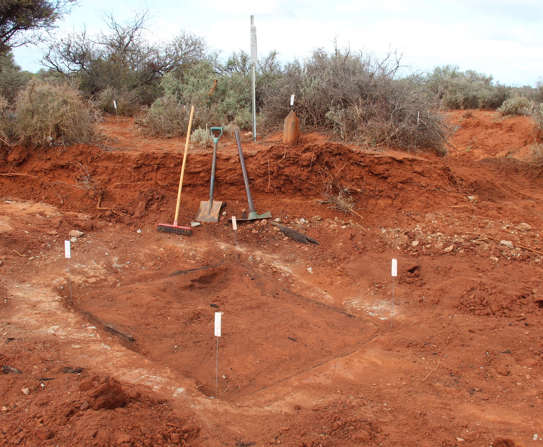
Slate Well & Post – Photo Eric Hancock
Eric’s research on a July 1893 ‘Yilgarn to Hampton Plains’ map showing all of the water supply points numbered commencing at H1 (Slate Well) following the track via Coolgardie, Gnarlbine, and Hunt’s Track back to Southern Cross. This map resulted from an expedition by surveyor Noel Murray Braziers in November-December 1892 immediately after the discovery of gold at Coolgardie. Braziers survey field book showed that the well was about three meters NNW of a post he installed marked H1. With this background research, the search was primarily for the H1 surveyor’s post, rather for the well in the bed of a creek that would be long covered over by silt and possibly changes to the creek location.
The general area of the well was known and Hunt’s own map provided some landscape features so after about an hour of searching, the site was found by Eric Hancock and Peter Green with the finding of the surveyor’s postmarked H1. There were also pieces of broken schist in the creek bank. No earth bank or other evidence has survived of Hunt’s associated Tank. The site is on Woolibar Station about four kilometers south of the homestead. This is private property not generally open to the public, so any site visits require prior permission. The station owner Matt James has been very supportive in assisting with access for research. The 1892 post is about four meters east of a north-south creek. The soil is red clay of around 1.3 meters overlaying the harder schist evidenced at the bottom of the adjoining creek and this clay was also covering the actual well site. A machine was required to remove the hard clay covering and a bobcat was made available by local supporter Fred Smith.
The excavation on Tuesday 24th May by Peter Green and Eric Hancock was more successful than ever imagined. It was expected to get down to the sedimentary bedrock at 1.3m and just find the well hole in the rock. The well was located where expected about 2.1m (to edge) nor-nor-west of the H1 post. From 400mm down they came across rock debris from the excavated well which would have originally formed a flat surface around the well – this has partly caved into the well in historical times. At another 300mm down they excavated the square well with arm thickness logs forming side walls – ‘pig pen’ form. The 1.6m square well sits in a larger round hole that has been backfilled to the sides of the ‘pig pen’. The west side of the well facing the creek has no backfill – only soil. Hunt did not strike water in the well and put a dam across the creek so it would back up and filtrate into the well. Inside the well is softer river sand type sandy/clay silt compared to the harder clay soil outside. The well collar in the bedrock would be a further 600mm down but excavation into the well would destroy the fragile remains of the ‘pig pen’ – this should only be attempted by qualified archaeologists and no more than 200mm past the top of bedrock, which they hope to arrange in the future. Given that the well did not strike permanent water, was little used and by the early 1890s was partly collapsed and even by then hard to find, it would be a waste of time fully excavating the well as it is doubtful that any artefacts of interest would be found. It would also do more damage to the ‘pig pen’.
Slate Well is one of but many Hunt’s Wells all with their own story and while Charles Cooke Hunt is still relatively unknown he played a crucial role in opening up of country east of York and ultimately the eastern goldfields. Hunt was born in England 1833. He joined the Royal Navy acquiring his Masters Certificate in 1859 but was injured and pensioned off. Arriving in Western Australia early 1863 with a new career as a surveyor and explorer Hunt also married Mary Ann Seabrook of Beverley in December 1864 and they had two children. In 1867 he worked as a road surveyor around Geraldton. By December he was very ill and sadly died of heart disease on 1st March 1868 at the age of only 35. He is buried at Geraldton in an unmarked grave.

Moya Sharp
Latest posts by Moya Sharp (see all)
- The Brewery on the Breakaway: Sandstone’s Beer-Making Marvel - 20/06/2026
- The Waitress, the Barman, and the Wife - 20/06/2026
- Lost for Love – The Tragedy of Beth Maynard - 20/06/2026
Leave a Reply